| ‘Bugden Palace’
Landscape History : Understanding the Site
Buckden Towers (Grid reference TL193678) lies at the heart of the village of Buckden equidistant by 4 miles from Huntingdon and St. Neots in the County of Cambridgeshire. The village is located in gently undulating lowland falling to the River Ouse in the east and rising to a height of 50m north west of the village. The clay soils, with a subsoil of Oxford clay, have given rise to a landscape dominated by arable farming with limited woodland. Gravel deposits beside the River Ouse have been subject to extraction, resulting in the creation of a number of lakes.
The Great North Road (the A1) that formerly passed through Buckden now follows a bypass to the west of the village. The proximity of this major arterial route has had important consequences for the settlement, both as the location for a palace serving the Bishops of Lincoln and as a halt for stagecoaches travelling between London, Lincoln and York.
The site is designated as a Scheduled Ancient Monument, contains Grade I, Grade Il’ and Grade ll listed buildings of Special Architectural and Historic Interest, forms part of the Buckden Conservation Area and has a number of trees which are protected by Tree Preservation Orders.
Medieval Period
It is likely that the moat was first constructed around the house and hall in the 12″ or 13″ century, perhaps to impress as a symbol of the Bishopric’s wealth and power in addition to providing a defence against unwelcome visitors. Spaces within the moat around the house and hall may have been cultivated as gardens to provide herbs for the kitchen. Daniel Defoe describes the House and Garden surrounded by a very large and deep Moat of Water.
The extent of the Bishop’s original land holding at Buckden is unknown. It was added to by various grants from the crown and by the early 13″ century included Buckden Great Park, situated north west of the village and shown as a characteristic oval deer park on early maps, The park was enclosed by a deep ditch and accompanying bank, the linear earthworks of which still survive in part”. Documents refer to the granting of deer leaps and enlargement. In 1330 the park was enlarged to include a further 200 acres and contained over 200 head of deer. By 1647 the Great Park encompassed 425 acres in total. Two moated sites lay within the Great Park, one of which, formerly the keeper’s house, still exists.
In addition to the Great Park there was a Little Park around the Palace, probably created at the same time or shortly after the Great Park. In 1329 a grant of Free Warren was made to Bishop Henry. Lower Coneygarth and Upper Coneygarth are shown on the Inclosure Map of 1813° west of the Little Park indicating the likely site of the warren.
The Bishop’s Palace is situated halfway between London and Lincoln adjacent to a major highway and is known to have entertained Henry ll in 1248 and Edward I in 1291. Hospitality for bishops and kings would have required the support of a considerable estate to accommodate visitor’s entourages and provide entertainment and food for the table. Documentary evidence and field names at enclosure suggest that the Great Park provided hunting and game, a warren to provide fresh meat, that there were coppice woodlands for fuel, pools for fish and wildfowl and a mill and vineyards.
There is limited surviving evidence of this period upon the site of the Bishops Palace and the Little Park but this period established land use patterns, earthworks and the location of buildings that influenced subsequent development and the framework of what
remains today.
15- 17th Century Development
The 15″ century saw a great deal of construction with the building of the tower, inner and Outer Gatehouses and the boundary wall and rebuilding of much of the adjoining church. By the late 16″ century the palace was in a state of disrepair, but Bishop Wiliams (1621 – 1641) restored and refurbished much of the accommodation and undertook considerable work in the grounds. The outward Courts he craft into fair Allies, and Grass-plats and liked to walk for two hours each day ‘where good Scents, and Works of well-formed Shape were about him. He developed ‘Gardens, Arbors, Pools for Water-fowl’ and a Walk raised three Foot from the Ground, of about a mile in compass, shaded and covered on each side with Trees and Pales’. ‘All the nurseries about London for fair Flowers, and choice Fruits were ransacked to furnish him. In addition he planted woods, fenced the (Great?) Park and stocked it with deer. Bishop Williams fell into disgrace with the King and the Palace was occupied by Kilvert, solicitor to the Star Chamber, who reputedly caused much damage. A survey of 1647 records the survival of many of the features inherited, adapted or created by Bishop Williams. These include the principal buildings enclosed by a moat, the outer court enclosed bya brick wall with an outer gateway; outbuildings, gardens and a fishpond; the Little Park with three fish ponds and the encircling raised path with a double row of trees.
During the Commonwealth (1649 – 1660) several buildings were demolished but Bishop Sanderson, appointed at the restoration, undertook repairs. He is credited with planting the large Plane trees in the Little Park. The linking of the fish ponds to form a single lake is thought to have taken place in the late 17″Wearly 18″ century but no documentary evidence has been seen to verify this.
Fifteenth century construction of the tower, gatehouses and boundary wall together with Bishop Wiliams’ boundary bank strengthened the hierarchy of spaces, definition and enclosure apparent today. Bishop Wiliam’s recorded work has been the inspiration for late 20″ century projects in the grounds of Buckden Towers.
18″ and 19″Centuries
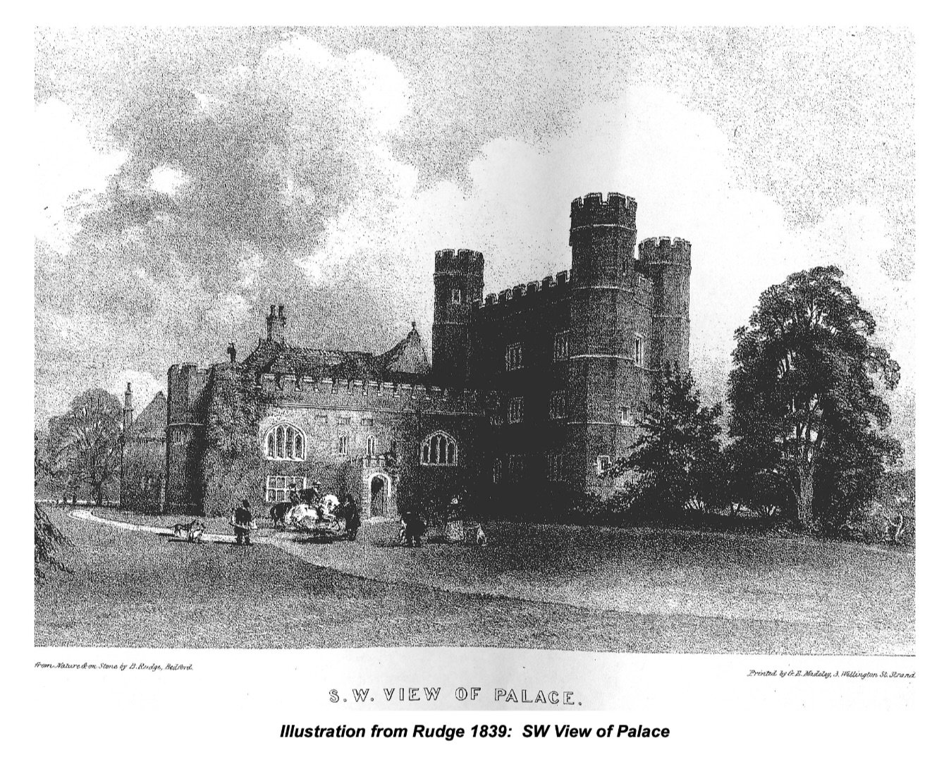
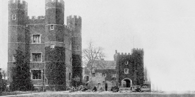
A print after Buck dated 1784 provides a westerly view of the Palace with the inner and Outer Gatehouses, the crenelated boundary wall and the moat passing between the tower and the church, all against a well treed backcloth. Bishop Pretyman-Tomline (1787-1820) filled up the moat on all but the west side during his tenure but otherwise there are few records of change to the landscape in the 18″ century. llustrations by John Buckler, 1799, show livestock in the Little Park, the remaining section of moat fenced and mature trees in the outer court, perhaps the walnut trees giving rise to its being referred to as the Walnut Court. Rudge’s lithographs, 1839, confirm the planting of the outer court, which is shown densely treed with mature specimens, and easterly views of the palace that include the lake in the foreground and suggest the planting of some coniferous specimens in the park. Early photographs” show the moat with two clear arches to the bridge, a high stepped wall attached to the Inner Gatehouse terminating the southern end of the moat and at least one mature tree north of the approach to the gatehouse. Another photograph, showing the tower, part of the Great Hall (?) and the inner court, possibly taken around the same time, and includes a timber rail fence that appears to separate the inner court from the Little Park.
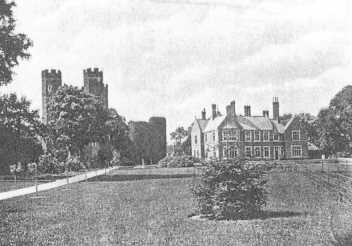
In 1869 the ecclesiastical commissioners sold the estate to Mr. James Marshall who intended the ancient buildings to be adapted to make a home for his son Arthur. His son appears to have favoured a new home so some existing buildings were demolished to make way for the new house and the western section of the moat was filled in. A photograph from the Outer Gatehouse looking towards the Inner Gatehouse and new house records the changed aspect of the outer court. Mature trees north of the approach have been removed to allow a clear view to the house from the entrance. Without the moat a new path passes directly north of the Inner Gatehouse to the main house entrance. Lawns in the outer court north of the main path are planted with Wellingtonia, estimated to be between 5 and 10 years old at the time the photograph was taken, and ornamental beds to the south that
include evergreens. A Country Life photograph of 1909* show the Wellingtonias both sides of the main path, while a later undated postcard shows the maturing Wellingtonias and mature shrubbery south of the path. Country Life photographs of 1909 indicate that the inner court was simply treated with level lawns and paths. A relatively new planting bed is shown defining the inner court from ground to the east, while a path lined with small standard trees or bushes leads from beside the tower towards the lake. There appears to be a grass bank indicating a change in level between the planting bed and path and the land to the east. Another photograph taken from a comparable angle but further away from the buildings indicates a large lawn extending towards the lake with the aforementioned path alongside, fences separating the garden from the park, and the large new’ house quite separate and apart from the tower and Inner Gatehouse.
The First Edition Ordnance Survey of 1887 indicates that the area south of the high stepped wall was laid out as a garden or orchard with a grid of paths and a separate building south of the Inner Gatehouse. It seems that in the late 19″ century the space became a kitchen garden for by 1901 three glasshouses are shown and the separate building, paths and trees have been removed. There is site evidence that the south facing side of the stepped wall accommodated a glasshouse and numerous nails in the boundary wall to the church yard indicate that this wall was probably used for supporting plants, possibly fruit trees and bushes. The Marshall’s work radically changed the property, removing principal buildings, adding a large new house set apart from the historic structure of the tower and Inner Gatehouse and developing garden areas planted in a contemporary style.
20 Century
Dr Robert Holmes Edelston, a Fellow of the Society of Antiquaries, bought the property after the First World War. He undertook various excavations and reconstructions using old materials. These included the construction of a wall along the eastern moat alignment
defining a space around the eastern side of the house and tower, and an extension to the Inner Gatehouse that blocked the view of the main house from the Outer Gatehouse.
In 1956 the Palace was given to the Claretian Missionaries. They erected the Church of Saint Hugh on part of the inner court, a Lady Chapel on the site of a medieval chapel and added St Stephen’s Hall north of the house on the edge of the Little Park (1962). Part of the park adjoining the church passed to the church commissioners for construction of a vicarage. There was limited maintenance of the grounds apart from the removal of dead trees, some new tree planting in the park to a scheme by the local authority (1978), grass cutting, use of the park as a sports field and use of the walled garden for allotments. Trespass and vandalism added to the air of neglect.
In 1988 David Jones, Superintendent of Parks and Gardens for the Corporation of the City of London was called upon to comment upon the grounds. His short report identified issues and made some proposals for improvement and maintenance. In 1991, William Dawson, a recently retired forester formerly with the Cambridgeshire Wildlife Trust, produced a plan for the grounds.
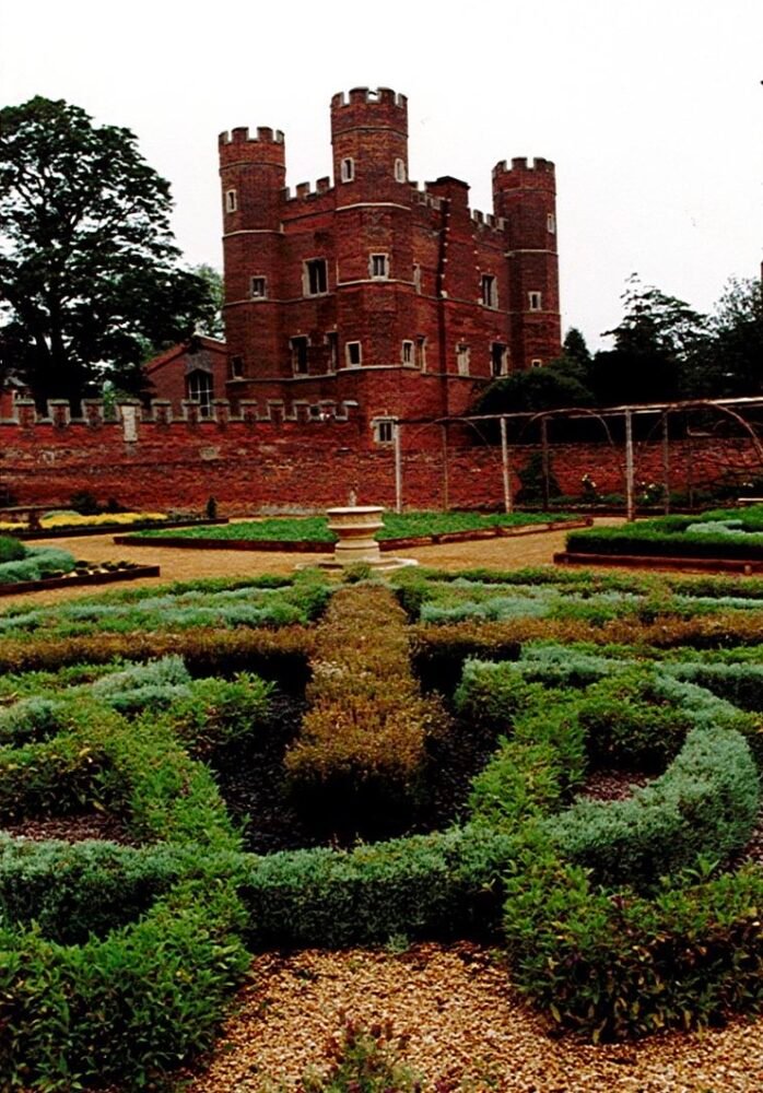
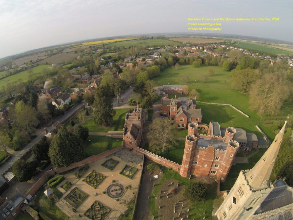
The proposals aimed to reflect Buckden Towers’ role ‘as a place for spiritual reflection and renewal, as a focus for community activities and quiet reflection and as a place of outstanding historical interest which draws visitors from all over the country. The proposalsincluded the re-establishment of an orchard and nuttery in the southern part of the Park; better delineation of the moat; cleaning out the fishpond, restoring the 17″ century raised walk and strengthening the woodland screen around the boundary of the Little Park and the parkland plantings.’ Also the creation of a ‘Spanish Court’ in the inner courtyard, a 16″ century knot garden on part of the allotments, the establishment of a pleached lime avenue, the planting of old shrub roses to the Edelston’s wall along the moat and constraints on car parking.
Apart from the Spanish Court and shelterbelt most of these proposals were realised in subsequent years with assistance from Anglian Water, the Countryside Commission, volunteers and the Friends of Buckden Towers. The knot garden was opened in 1994
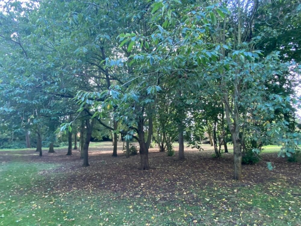
and is maintained by a small group of volunteers. A car park was created north west of the house adjacent to the Hall. Trees have been planted in the park that has been fenced and grazed in recent years.
20 century developments have sought to enhance the historic quality of the site and reflect features that have been removed. The work has comprised repair, re creation and creation. It has involved local people, volunteers and people on community service. The grounds are used, cared for and appreciated by residents and visitors.